Indian cities are starting to look boringly similar on the ground. The roads look similar, and so do some of the malls, buildings, apartment complexes and shops. Watching a city while approaching it in an aircraft, train or by road gives a perspective on the landscape on which it is built upon.
Landing at Chennai, one would see many irrigation tanks. These are usually depressions in which a mud or masonry wall has been constructed at the deep end, with a spillway allowing excess water to flow back into the stream. Downstream, not very far from this tank, would be another, for which the inlet stream will be from the outlet of the earlier one. These networks of water bodies are visible when driving into the city from the adjoining Thiruvallur or Chengelput districts.
There were many lakes in Chennai, which have mostly been built in over the decades. The four rivers traversing from west to east have had their flood plains constructed over. The Buckingham Canal that runs through the city on a north-south axis has constrictions in its path. The complex of wetlands near the Pallikaranai marsh has disappeared to a significant extent.
Ecological fault lines

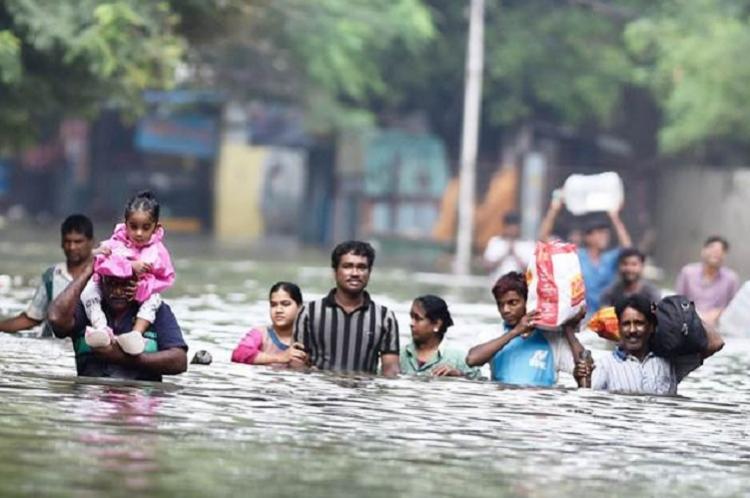
The end-2015 flood highlighted these ecological fault lines. The floods hits those areas worst that were once part of the wetland and water body network. The southern localities around the Pallikaranai marsh were the worst hit. Even in other localities, those who were not even aware that they were living on former lakebeds realised the flood water was higher in their homes than in other areas. The flood along the Adayar river spared none in its path, including the super rich, slum dwellers, patients in intensive care units of a hospital, and a housing complex built for senior civil servants.
The city responded in interesting ways. Somewhere, there was an inherent resilience built in, which came into effect during the crisis. A study on Chennai’s resilience prepared by IFMR Lead and TARU Leading Edge for the Asian Cities Climate Change Resilience Network shows that in addition to response by the fire services, police force and the National Disaster Management Agency, there were many innovative responses.
For instance, the report states that to reach food to the stranded, a restaurant called Kolapasi opened its kitchen and delivery systems. At a time 300 volunteers cooked for 170,000 people. Volunteers ranged from university students to businessmen, and even the elderly helped in the kitchen. They used social media to raise funds and identify where to take the food. The report also notes a supermarket chain stored and supplied essential commodities at a reduced price so as to help families recover.
To help families start their kitchens as early as possible, Servals Pvt Ltd, a company that specialises in energy-efficient stoves, supplied their units to families that were outside the government’s distribution networks.
Call a boat

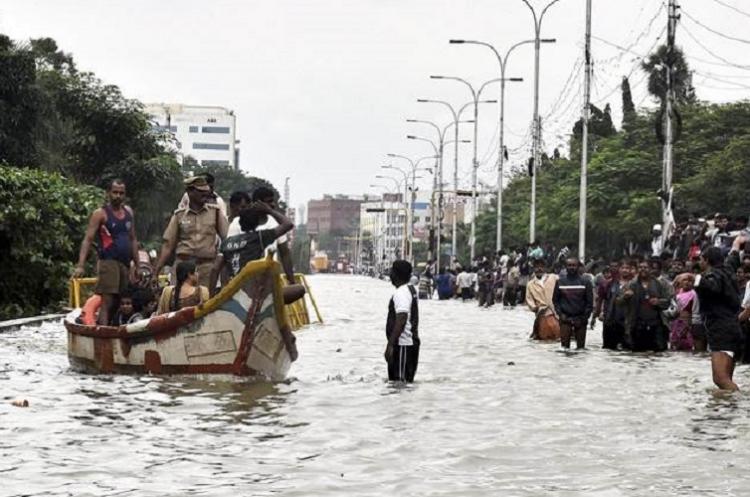
The most innovative move was by call taxi aggregator Ola, which turned itself into a call boat aggregator during the flood. They commissioned small fishing boats and vessels to help rescue people and also doubled as a call boat taxi service. The image of fishing boats with Ola stickers became one of the iconic images from the floods. The picture of a well-known industrialist escaping the floods on a fishing boat from his estate on the banks of the Adayar river was another iconic image from the floods.
It was the social and informal media that took centre-stage during the floods. Messages shared on Facebook, Twitter and other sites helped save lives, rescue people and reach food to those stranded. These worked from outside the city and from those localities where power and telephone connectivity returned comparatively quickly.
Bengaluru had become the operations centre for much of this. Arun Ganesh, a digital mapmaker, along with his friend designed a crowd-sourced map where residents could feed information on how deep water was at any point on any street. This was launched on December 1, 2015, and was immediately picked up by Chennai residents. At any given time during the floods there were at least 100 people accessing it. Flooding was reported from 15,000 road segments and in the two weeks of its launch it had registered 1.2 million views.
People from Chennai working outside the state wanted to pitch in. A group of Indian Administrative Service officers from Tamil Nadu working in other states got together and started a call centre in Bengaluru. It was established at the Karnataka Urban Water Supply and Drainage Board office by the then managing director P. Manivannan. Helping him to work at the call centre were young professionals from Chennai working in Bengaluru. They knew the geography of Chennai, and were well placed to receive distress calls and direct relief.
Weather watcher
Pradeep John, an amateur weather watcher, found great traction for his Facebook posts and tweets. He had practical advice on when the next spell of rain was coming, how intense it would be and how long it would last. John became an overnight celebrity, and his postings under the name of Tamil Nadu Weatherman has an increasing number of followers ever since.
Radio jockey Balaji, actor Siddharth and singer Chinmayi formed another group that aggregated calls for help through social media and directed help to where it was needed. The social media momentum continued when the city faced other extreme weather events such as Cyclone Vardah and the drought of summer 2017. It was also used as the youth of Tamil Nadu congregated at the Marina Beach to protest against the ban on traditional bull racing, or jallikattu.
Did Chennai learn from the crisis and take steps to deal with future events? Although the rains were not as severe as that during end-2015, exactly a year later when Cyclone Vardah struck, municipal authorities were quicker with their response. With gale winds reaching 140 km per hour, Vardah brought down nearly 20,000 trees in the city. The corporation could clear these trees off the roads in the next few days. Also, power, phone and Internet connectivity were restored faster.
Stop the mafia

But this still does not mean that the city will not flood with the next rains. A Parliamentary Standing Committee on the Chennai floods notes in its report on August 12, 2016, that the encroachment of lakes and river beds played a major role in causing the floods. “The Committee feels that the State Government should check the mafia involved in illegal construction for business and usurping water bodies for their real estate business. The flood channels and riverbed should be cleared as soon as possible by removing illegal/unauthorized constructions.”
Obviously, this has not happened. The river channels have been dredged and widened in some places, but the river mouths (including the mouth of Pallikaranai marsh at Muthukadu) continue to be blocked by sand bars.
The government authorities had argued before the committee that since the end-2015 flood was a one-in-a-hundred-year event, it would be impossible to prevent the damages. The parliamentarians found this unacceptable. “The Committee does not quite accept the argument that since the rainfall was unprecedented and was more than the hundred years average therefore the damage was also huge.”
The citizens of Chennai are scared because rain events of even lesser intensity have been causing waterlogging and floods in the past few years. The further the city moves from the original landscape on which it was built, greater is the risk of floods.
Source: http://indiaclimatedialogue.net/2017/10/25/chennai-learn-anything-2015-floods/


